|
|
History |
Demographics | Administration
| Culture | Economy |
Transport | Telecommunication|
Parks- & Gardens | Sports
| Media | Rawalpindi (Urdu: راولپنڈی)
Rāwalpindī) is a city in the Majha region of Punjab near Pakistan's capital
city of Islamabad, in the province of Punjab. Rawalpindi is the fourth
largest city in Pakistan after Karachi, Lahore and Faisalabad. Locally known
as Pindi, the area was home to the pre-historic Soanian culture indigenous
to this region. Numerous shopping bazaars, parks and a cosmopolitan
population attract shoppers from all over Pakistan and abroad. In the 1950s,
Rawalpindi was smaller than Hyderabad and Multan, but the building of
Islamabad in the 1960s boosted the city's economy, resulting in a tenfold
increase in population, from 180,000 to over 2.1 million.
Rawalpindi is also the military headquarters of the Pakistan Armed Forces
and also served as the nation's capital whilst Islamabad was being
constructed in the 1960s. The city is home to several industries and
factories. Islamabad International Airport, formerly known as "Chaklala"
airport, now known as "Benazir Bhutto International Airport" is actually in
Rawalpindi; it serves the city along with the capital. Rawalpindi is located
in the Punjab province, 275 km (171 miles) to the north-west of Lahore. It
is the administrative seat of the Rawalpindi District. The total area of the
city is approximately 154 square kilometres (59 sq mi). It is a bustling
town strategically located between the Punjab and Azad Kashmir. Many
tourists use the city as a stop before traveling towards the northern areas.
Search Rawalpindi on
Satellite Map
Places of Interest
| Hotels |
Eating &
Dining | Parks &
Gardens |
Educational Institutes |
Hospitals |
Sport Centers |
Banks |
ATM |
Fuel
Stations | CNG
Stations | Police
Stations |
Shopping /Trade
History
 Rawalpindi has been inhabitied for thousands of years, it is believed that a
distinct culture flourished on this plateau as far in c1000BC. The material
remains found at the site prove the existence of a Buddhist establishment
contemporary to Taxila and of a Vedic civilisation. The nearby town of
Taxila has another significance; according to the Guinness Book of World
Records it has the world's oldest university - Takshashila University. Rawalpindi has been inhabitied for thousands of years, it is believed that a
distinct culture flourished on this plateau as far in c1000BC. The material
remains found at the site prove the existence of a Buddhist establishment
contemporary to Taxila and of a Vedic civilisation. The nearby town of
Taxila has another significance; according to the Guinness Book of World
Records it has the world's oldest university - Takshashila University.
Sir Alexander Cunningham identified certain ruins on the site of the
cantonment with the ancient city of Gajipur or Gajnipur, the capital of the
Bhatti tribe in the ages preceding the Christian era. Graeco-Bactrian coins,
together with ancient bricks, occur over an area of 500 ha (2 mi²). Known
within historical times as Fatehpur Baori, Rawalpindi fell into decay during
one of the Mongol invasions in the fourteenth century.
It appears that the ancient city went into oblivion as a result of the White
Hun devastation. The first Muslim invader, Mahmud of Ghazni (979-1030), gave
the ruined city to a Gakhar Chief, Kai Gohar. The town, however, being on an
invasion route, could not prosper and remained deserted until Jhanda Khan,
another Gakhar Chief, restored it and named it Rawalpindi after the village
Rawal in 1493. Rawalpindi remained under the rule of the Gakkhars until
Muqarrab Khan, the last Gakkhar ruler, was defeated by the Sikhs under
Sardar Milka Singh in 1765. Singh invited traders from the neighbouring
commercial centres of Jhelum and Shahpur to settle in the territory.
Early in the nineteenth century Rawalpindi became for a time the refuge of
Shah Shuja, the exiled king of Afghanistan, and of his brother Shah Zaman.
The present native infantry lines mark the site of a battle fought by the
Gakhars under their famous chief Sultan Mukarrab Khan in the middle of the
eighteenth century. Rawalpindi was taken by Sikh ruler Maharaja Ranjit Singh
in 1818. It was at Rawalpindi, on March 14, 1849, that the Sikh army under
Chattar Singh and Sher Singh finally laid down their arms after the battle
of Gujrat and were decisively defeated
British Rule
Following the British invasion of the region and their occupation of
Rawalpindi in 1849, the city became a permanent garrison of the British army
in 1851. In the 1880s a railway line to Rawalpindi was laid, and train
service was inaugurated on 1 January 1886. The need for a railway link arose
after Lord Dalhousie made Rawalpindi the headquarters of the Northern
Command and the city became the largest British military garrison in British
India.
On the introduction of British rule, Rawalpindi became the site of a
cantonment and, shortly afterward, the headquarters of 2nd (Rawalpindi)
Division. Its connection with the main railway system by the extension of
the North-Western Railway to Peshawar immensely developed its size and
commercial importance. The municipality was created in 1867.
 The income and expenditure during the ten years ending 1902-3 averaged 2–1
lakhs. In 1903-4 the income and expenditure were 1-8 lakhs and 2-1 lakhs
respectively. The chief item of income was octroi (1-6 lakhs); the
expenditure included administration (Rs. 35,000), conservancy (Rs. 27,000),
hospitals and dispensaries (Rs. 25,000), public works (Rs. 9,000), and
public safety (Rs. 17,000). The cantonment, with a population in 1901 of
40,611, was the most important in all of British South Asia. It contained
one battery of horse and one of field artillery, one mountain battery, one
company of garrison artillery, and one ammunition column of field artillery;
one regiment of British and one of Native cavalry; two of British and two of
Native infantry; and two companies of sappers and miners, with a balloon
section. It was the winter headquarters of the Northern Command and of the
Rawalpindi military division. An arsenal was established here in 1883. The income and expenditure during the ten years ending 1902-3 averaged 2–1
lakhs. In 1903-4 the income and expenditure were 1-8 lakhs and 2-1 lakhs
respectively. The chief item of income was octroi (1-6 lakhs); the
expenditure included administration (Rs. 35,000), conservancy (Rs. 27,000),
hospitals and dispensaries (Rs. 25,000), public works (Rs. 9,000), and
public safety (Rs. 17,000). The cantonment, with a population in 1901 of
40,611, was the most important in all of British South Asia. It contained
one battery of horse and one of field artillery, one mountain battery, one
company of garrison artillery, and one ammunition column of field artillery;
one regiment of British and one of Native cavalry; two of British and two of
Native infantry; and two companies of sappers and miners, with a balloon
section. It was the winter headquarters of the Northern Command and of the
Rawalpindi military division. An arsenal was established here in 1883.
It has been recently disclosed that the British Government tested poison gas
on Indian troops during a series of experiments that lasted over a decade
After Independence
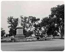
In 1951, Rawalpindi saw the assassination of the first elected Prime
Minister of Pakistan, Liaquat Ali Khan in Company Bagh now known as Liaquat
Bagh Park (also called Liaquat Garden.) On 27 December 2007, Liaquat Bagh
Park's rear gate in Rawalpindi was the site of the assassination of former
Prime Minister Benazir Bhutto. Her father, former Prime Minister Zulfikar
Ali Bhutto was hanged in Rawalpindi in 1979.
The famous Murree Road has been a hot spot for various political and social
events. Nala Lai, in the middle of city, history describes Nala Lai water as
pure enough for drinking but now it has become polluted with the waste water
from all sources including factories and houses. Kashmir Road, was renamed
from Dalhousie Road, Haider road from Lawrence road, Bank Road from Edwards
Road, Hospital Road from Mission Road, Jinnah Road from Nehru Road. Today
Rawalpindi is the headquarters of the Pakistani Army and Air Force
Find more about
History of Pakistan
Go To Top
Demographics
The population of Rawalpindi is approximately 3,039,550 according to the
2006 census which includes many people who come from Punjab villages looking
for work in the city. The majority of the people of Rawalpindi are Muslims.
There are many mosques throughout the city. The most famous Mosques are
Jamia Mosque, Raja Bazaar Mosque and Eid Gah Mosque which attract thousands
of visitors daily. Other minority religions are Christian, Zorastrian, Bahai,
Parsi, Hindu, Sikh and Ahmadiyya Religion. The literacy rate is 70.5%
(January 2006). The population is ethnically and linguistically
heterogeneous, comprising Pothoharis, Punjabis,Paharis, Kashmiris, Pakhtuns,
Gilgiti, Muhajirs, Hindkowans and Afghans.
Go To Top
Administration
The City-District of Rawalpindi comprises eight autonomous tehsils, besides
Rawalpindi city (divided into Rawal & Potohar Tehsils):
Today Rawalpindi is the headquarters of the Pakistani Army and Air Force.
The famous Murree Road has been a hot spot for various political and social
events. Nala Lai, in the middle of city, history describes Nala Lai water as
pure enough for drinking but now it has become polluted with the waste water
from all sources including factories and houses.
Kashmir Road, was renamed from Dalhousie Road, Haider road from Lawrence
road, Bank Road from Edwards Road, Hospital Road from Mission Road, Jinnah
Road from Nehru Road.
Rawalpindi also holds many private colony's who have developed them selves
rapidly for eg baharia town which is the Asia's largest private colony
Go To Top
Culture
 Rapidly developing into a large city, Rawalpindi has many good hotels,
restaurants, clubs, museums and parks, of which the largest is the Ayub
National Park. Rawalpindi forms the base camp for the tourists visiting the
holiday resorts and hill stations of the Galiyat area, such as Murree,
Nathia Gali, Ayubia, Rawlakot, Muzaffarabad, Bagh, Abbottabad, Swat, Kaghan,
Gilgit, Hunza, Skardu and Chitral. Rapidly developing into a large city, Rawalpindi has many good hotels,
restaurants, clubs, museums and parks, of which the largest is the Ayub
National Park. Rawalpindi forms the base camp for the tourists visiting the
holiday resorts and hill stations of the Galiyat area, such as Murree,
Nathia Gali, Ayubia, Rawlakot, Muzaffarabad, Bagh, Abbottabad, Swat, Kaghan,
Gilgit, Hunza, Skardu and Chitral.
The city has two main roads: the Grand Trunk Road runs roughly from east to
west and is known as The Mall as it passes through the cantonment. Murree
Road originates toward north from The Mall, crosses the railway lines and
brushes the east end of the old city on its way to Islamabad.
The two main bazaar areas are Raja Bazaar in the old city and Saddar Bazaar,
which developed as the cantonment bazaar between the old city and The Mall.
Another developing market is the Commercial Market in the area of Satellite
Town near Islamabad.
The crowded alleys of the old city are home to many attractions, including
Hindu (in ruins now), Zorastrian, Sikh temples and Islamic shrines. There
are several museums and arts galleries such as the Lok Virsa, Pakistan
Museum of Natural History, and the $Idara Saqafat e Pakistan.
Rawalpindi has been a military city since colonial times and remained Army
headquarters after independence in 1947. Due to this, the city is home to
the Pakistan Army Museum, with displays on colonial and present day armies,
armoury of historical significance and war heroes.
Ayub National Park is located beyond the old Presidency on Jhelum Road. It
covers an area of about 2,300 acres (930 ha) and has a playland, lake with
boating facility, an aquarium and a garden-restaurant. Rawalpindi Public
Park is on Murree Road near Shamsabad. The Park was opened to the public in
1991. It has a playland for children, grassy lawns, fountains and flower
beds.
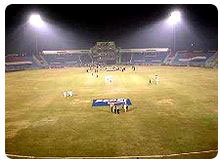 Rawalpindi Cricket Stadium, built in 1992, has a grass pitch, floodlights,
and a initial capacity of 20,000. In mid-2008 it was being upgraded and to
hold more than 40,000 people. The home team is the Rawalpindi Cricket
Association. The Rawalpindi Hockey stadium is a small but well-built
facility that plays host to the national side throughout the year. Rawalpindi Cricket Stadium, built in 1992, has a grass pitch, floodlights,
and a initial capacity of 20,000. In mid-2008 it was being upgraded and to
hold more than 40,000 people. The home team is the Rawalpindi Cricket
Association. The Rawalpindi Hockey stadium is a small but well-built
facility that plays host to the national side throughout the year.
Rawat Fort is 17 km (11 mi) east of Rawalpindi, on the Grand Trunk (G.T.)
Road leading to Lahore. Gakhars, a fiercely independent tribe of the
Pothohar Plateau, built the fort in the early 16th century. The grave of a
Gakhar Chief, Sultan Sarang Khan is inside the fort. He died in 1546
fighting against the forces of Sher Shah Suri. A climb up the broken steps
inside the tomb is rewarded with a panoramic view of the plateau and the
Mankiala Stupa. Besides Rawat, about an hour's drive from Rawalpindi on the
Grand Trunk Road toward Peshawar, is Attock Fort. This impressive fort is
easily visible and near the Shrine 'Hazrat Jee Sahib', the tradition burial
grounds for the 'Bati' family of the Paracha clan from the near by
(deserted) village of 'Malahi Tola'. The Akbari fort is not open to the
public as it is in active military use.
Pharwala Fort is about 40 km (25 mi) from Rawalpindi beyond Lehtrar road. It
is a Gakhar fort built it in the 15th century on the ruins of a 10th century
Hindi Shahi Fort. Emperor Babur conquered the it in 1519. Later, in 1825,
Sikhs expelled Gakhars from this fort. Though in a crumbling state, it is
still an attraction for castle lovers. The fort, situated in prohibited
area, is only open to Pakistani visitors.
Rawalpindi has numerous sights of architectural masterpieces. A few of the
heritage buildings are Purana Qil'aa (The Old Fort), Bagh Sardaran (Chief's
Gardens), Haveli Sujaan Sigh (the remains of the Sikh Nawabs of Rawalpindi;
the grand building has been converted into Fatima Jinnah Women University,
which is the only female university established in the region).
Other ancient buildings include Jain Mandir, Jain Temple. Gordon College, a
prestigious institution of high learning was set during the British Raj. The
shrine of Hazrat Sakhi Shah Chan Charagh is one of the centres devotees
flock to. An institution of high devotion and solace located near the famous
Raja Bazar. He is the patron saint of the city and regarded as one of the
two protectors of the twin cities, i.e., Islamabad and Rawalpindi, with
Hazrat Bari Imam, his cousin brother.
The Rawalpindi Public Library was one of the earliest private public
libraries organized after separation from India. The building was donated
for a public library by the then-Deputy Commissioner Major Davis on the
initiative of philanthropist Khurshid Anwar Jilani, an attorney, writer and
social worker. However, the building was confiscated for election and
political campaigning during the last days of Field Marshal Ayub Khan's
reign, and rare manuscripts and artifacts were taken away by the influential
Find more about
Culture of Pakistan ,
People, Art & Culture
Go To Top
Economy
 According to the general survey of industry conducted by Directorate of
Industries and Mineral Development Punjab, there are 939 industrial units
operating in the district. This district is not famous for industrial goods
like other districts. The progress has been mostly in the private sector.
The existing industrial units provide employment to about 35,000 people,
i.e., about 1.6% of district population is directly employed in large,
medium and small industrial units. According to the general survey of industry conducted by Directorate of
Industries and Mineral Development Punjab, there are 939 industrial units
operating in the district. This district is not famous for industrial goods
like other districts. The progress has been mostly in the private sector.
The existing industrial units provide employment to about 35,000 people,
i.e., about 1.6% of district population is directly employed in large,
medium and small industrial units.
Apparently there is no shortage of skilled manpower. The
Technical/Vocational Training Institute operating in the district turns out
about 1,974 technicians/artisans annually. They are trained in engineering,
air conditioning, drafting, metallurgy, welding, auto knitting and commerce,
etc.
Kohinoor Textile Mills is the largest unit in the district. It is located
near Naseer Abad and is equipped with 50,000 spindles and 1,021 power looms.
Wattan Woolen and Hosiery Mills is fitted 10,000 spindles.
Rahat Woolen Mills, established in 1954, is one of the oldest and most
prominent mills in Rawalpindi.
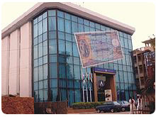
Jinnah Road, formally known as City Saddar Road, is one of the busiest
business markets. It could be considered as business headquarters northern
Pakistan including retailers, wholesalers, distributors, manufacturers
having an approximately cash flow of more than 1 billion per day. The
importance of Jinnah Road can be seen by the presence of more than nine
banks on the road with more opening soon.
Find more about
Worldwide
Business & Economy
Go To Top
Transport
Rail
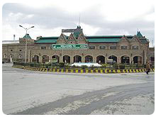 The Rawalpindi Railway Station is located in the Saddar City. The Railway
Station was built in the 1880s by the government of British India. The
British built many railways across South Asia to help facilitate trade and
more importantly to help consolidate their rule. The routes the British
built from Rawalpindi, which contained a major military base, linked to
Lahore, Karachi, Peshawar, Quetta, Multan, Faisalabad, Hyderabad, Sindh,
Sukkur, Bahawalpur, Jhelum, Gujrat, Gujranwala, Kohat, Khanewal, Nawabshah,
Nowshera and the Malakand Pass The Rawalpindi Railway Station is located in the Saddar City. The Railway
Station was built in the 1880s by the government of British India. The
British built many railways across South Asia to help facilitate trade and
more importantly to help consolidate their rule. The routes the British
built from Rawalpindi, which contained a major military base, linked to
Lahore, Karachi, Peshawar, Quetta, Multan, Faisalabad, Hyderabad, Sindh,
Sukkur, Bahawalpur, Jhelum, Gujrat, Gujranwala, Kohat, Khanewal, Nawabshah,
Nowshera and the Malakand Pass
Airport
Benazir Bhutto International Airport is actually located at Chaklala which
technically is a part of Rawalpindi. The airport is served by over 25
airlines, both national and international. Pakistan International Airlines (PIA),
the national carrier of Pakistan, has numerous routes, with many domestic
and international flights every day. Construction on the new Rawalpindi/Islamabad
international airport has now been started near the town of Fateh Jang
approx 25 kilometres (20 mi) from both cities
Motorway
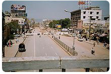
The main route running through Rawalpindi is the Murree Road. This road runs
West-East through the city and continues to the hill station of Murree,
which is a major summer attraction for Rawalpindi residents. Murree Rd is
one of the busiest roads in the Punjab Province of Pakistan.
Rawalpindi is on the ancient Grand Trunk Road (also known as G.T. Road or,
more recently, N-5) which links Rawalpindi to nearly every major city in
northern Pakistan, from Karachi, to Peshawar, Lahore, Quetta, Multan,
Faisalabad, Hyderabad, Sukkur, Bahawalpur, Jhelum, Gujrat, Gujranwala, Kohat,
Khanewal, Nawabshah, Nowshera and the Malakand Pass.
The city is also served by two nearby six-lane Motorways, M2
(Lahore-Islamabad) and M1 (Islamabad-Peshawar), which were completed in the
1990s. Somewhat further away is the famous Karakoram Highway, the world's
highest international road, which connects Pakistan to China
Go To Top
Telecommunication
The PTCL provides the main network of landline telephone with minority
shares of other operators. All major mobile phone companies operating in
Pakistan provide service in Rawalpindi. Broadband internet access is
available from DSL, FTTH to state of the art WiMax technology from many ISP,
WiMax and WiFi operators like Witribe,Wateen,Micronet,Nayatel etc
Go To Top
Parks & Gardens
Ayub National Park formerly known as "topi rakh" (stay hat or remove hat) is
located by the old Presidency, and between the Murree Brewery Co. and Grand
Trunk (G.T.) Road. It covers an area of about 2,300 acres (930 ha) and has a
play area, lake with boating facility, an aquarium, a garden-restaurant and
an open air theater. This park hosts 'The Jungle Kingdom' which is
particularly popular among young residents of the city.
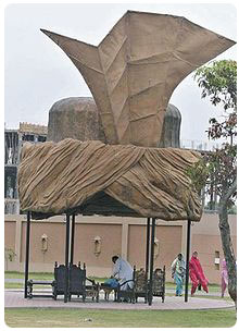
Liaquat Bagh formerly known as the "company bagh" (East India Company's
Garden), is of great historical interest. The first prime minister of
Pakistan, Liaquat Ali Khan, was assassinated here in 1950. Pakistan's Prime
Minister Banazir Bhutto was assassinated here on 27 December 2007. She was
the youngest elected Prime Minister of the world.
 Rawalpindi Golf Course was completed in 1926 by Rawalpindi Golf Club, one of
the oldest golf clubs of Pakistan. The facility was initially developed as a
nine-hole course. After several phases of development, it is now a 27-hole
course. From the clubhouse, there is a panoramic view of Faisal Mosque, the
twin cities of Islamabad and Rawalpindi, and the course itself. Major golf
tournaments are regularly held here. Rawalpindi Golf Course was completed in 1926 by Rawalpindi Golf Club, one of
the oldest golf clubs of Pakistan. The facility was initially developed as a
nine-hole course. After several phases of development, it is now a 27-hole
course. From the clubhouse, there is a panoramic view of Faisal Mosque, the
twin cities of Islamabad and Rawalpindi, and the course itself. Major golf
tournaments are regularly held here.
Rawalpindi Public Park (also known as Nawaz Sharif Park) is located on
Murree Road. The Park was opened in 1991. It has a play area for children,
lawns, fountains and flower beds. A cricket stadium was built in 1992
opposite the Public Park. The 1996 World Cup cricket matches were held on
this cricket ground.
Playland is another public located parallel to Ayub Park, its nearness to
many classy colonies and housing schemes makes this wonderland an attractive
hotspot during the holidays.
 Liaquat National Bagh Liaquat National Bagh
Jinnah Park
Ayub Park
DHA Jungle Park
Rumi Park
Shah Balot Park
Race Course
Ladies & Childrens Park, Dhoke Hassu
Children Park in Commercial Market
502 Workshop Park (Zia Park) Lalazar
Dussehra Ground Asghar Mall
Ladies & Childrens Park, Gawalmadi
Satellite View of Parks & Gardens
Go To Top
Sports
The city has an array of stadiums and grounds to meet the needs of all the
popular sports played in the country.
Rawalpindi is home to some of the most recognised players in the history of
Pakistani cricket. The Rawalpindi Cricket Stadium is the official cricket
stadium used for international tests and ODIs. However, there are plenty of
other cricket grounds such as Army Cricket ground (home to the Pindi Club),
KRL Cricket ground, CMTSD Cricket stadium as well as the Attock Oil Refinery
cricket ground.
There are stadiums for hockey such as the Army Hockey Stadium, Army Signals
Hockey ground as well as the Noor Station Ground Dhoke Hassu. There are
stadiums for football including the Municipal Football stadium and the Army
Football ground. Other sports complexes include the COD Sports Complex and
the Railway Ground Dhoke Matkial.Kabadi.
Satellite View of Sports Centers
Go To Top
Media
Rawalpindi, being so close to the capital, has an active media and newspaper
climate. There are over a dozen of newspaper companies based in the city
including Daily Nawa-i-Waqt, Daily Jang, Daily Islamabad Times, Daily Asas,
Daily Times, Daily Nation, National Herald Tribune, The Daily Sada-e-Haq,
Daily Express, Daily Dawn, Daily Din, Daily Aajkal Rawalpindi, Daily Islam,
and Daily Pakistan.
Find more about
Media & News in Pakistan
, Worldwide Media &
News
Go To Top
|