|
|
History
| Religion | Languages
| Geography | Education |
Culture and Economy |
Transport |
Private Hospitals & Laboratories
| Society | Important
Buildings | Historical Places
 Mirpur Khas District (Urdu: میرپور خاص
) is one of the districts in the province
of Sindh, Pakistan. According to the 1998 census of Pakistan, it had a
population of 1,569,030 of which 18.60% Mirpur Khas District (Urdu: میرپور خاص
) is one of the districts in the province
of Sindh, Pakistan. According to the 1998 census of Pakistan, it had a
population of 1,569,030 of which 18.60%
It is the fifth largest city in the province with an estimated population of
488,590 (2009). Its soil is fertile and the city is known for its
horticultural produce and farming, of which the most celebrated is mango
cultivation, with hundreds of varieties of mangoes produced each year.
Search Mirpur Khas on Satellite
Map
Places of
Interest | Hotels |
Eating &
Dining | Parks &
Gardens |
Educational Institutes |
Hospitals |
Sport Centers |
Banks |
ATM |
Fuel Stations
| CNG Stations |
Police Stations
|
Shopping /Trade
History
After the capture of Sindh by the British, they created Thar and Parkar
District in Southeastern Sindh for administrative purposes. Later, after the
creation of Pakistan, some area on the northern side was detached from the
original Tharparkar District and named Sanghar District. Later, due to
political and administrative reasons, the remaining part of Tharparkar was
divided again into three more districts: (1) Mirpurkhas District (with
headquarters at Mirpurkhas), (2) Tharparkar District (with headquarters at
Mithi) and (3) Umerkot District.
Prior to the Islamic conquest of Sindh by the Arabian armies of Muhammad Bin
Qasim, the land where Mirpur Khas now stands used to be a thriving Buddhist
settlement known as Kahoo Jo Daro. The remnant stupa still remains and as
the armies settled in the area, newer buildings occupied the land and led
into massively progressive landscapes. Farming became known to people and
horticulture and cotton fields blossomed.
In 1806, Mankani Talpurs shifted their capital from Keti Mir Tharo and laid
foundations for Mirpur Khas under the leadership of Mir Ali Murad Talpur.
Mir Sher Muhammad Talpur succeeded Mir Ali Murad and built a fort when
declared the ruler of the state. He would run a kutchery from within the
fort. Mirpurkhas remained capital of Talpur Mirs of Mirpurkhas until 1843
when Sindh was annexed to British India under East India Company. When
Charles James Napier attacked Sindh, Mir Sher Muhammad Talpur was the last
Talpur ruler to face the British on 24 March 1843 at the battleground of
Dubbo. His battle for the liberation of Sindh has rendered him the title of
'the lion of Sindh'. The kutchery in the fort now has a tablet embedded at
the entrance reading, "The fort within which this building stands was
residence of Mir Sher Muhammad Khan, the Lion of Sind."
Later Sindh was made part of Bombay Presidency and Mirpurkhas was a part of
it. Umerkot was made the district's head-quarter town and Mirpur Khas was
ignored until the advent of the Luni-Hyderabad branch of the Jodhpur-Bikaner
Railway, a subsidiary of the Scinde Railway to the town. The opening of the
Jamrao Canal in 1900 made Mirpur Khas stand out of the rest of the towns in
the district. It was constituted a municipality in 1901 and was made the
district head-quarter in 1906.
At the turn of the twentieth century, the population of the town was 2,787
with a density of 82 persons per square mile, however the district, as a
whole, saw significant growth in the rise of population from 27,866 (1891)
to 37,273 (1901). The cotton produced at Mirpur Khas was considered the best
in the country when surveyed and the British exploited the produce by
exporting it to other nations.
After the partition, because of its proximity with the Indian border, Mirpur
Khas became the first city to welcome refugees from the newly found Indian
nation to Pakistan. It acted as a primary railway junction for the first
trains to rail across the Rajistan to the Sindh province
Go To Top
Religion
-
Islam: 86.37%
-
Hinduism: 12.73%
-
Christianity: 0.50%
-
Ahmadiyya: 0.27%
-
Others: 0.12%
Go To Top
Languages
It should be noted here that
Urdu speakers account for the largest group in the urban area of the
district at 47.92% followed by Sindhis at 28.71%.
Go To Top
Geography
Lying on the Let Wah Canal at 25°31'39.3?N 69°00'50.6?E? / ?25.527583°N
69.014056°E? / 25.527583; 69.014056, Mirpur Khas is the gateway to the
south-eastern edge of the Sindh province. It connects to Hyderabad at
65-kilometres by both road and rail while with Umerkot it connects only by
road. Karachi is 220-kilometres south-west to the town. On the extreme east
lies the Indian border at 170-kilometres.
Mirpur Khas is positioned atop a fertile land making conditions apt for
farming and irrigation. Being connected to the Indus via irrigation canals
like the Let Wah, Mirpur Khas has gained an advantage in horticulture and
farming over the years. Primary produce includes mangoes (famous for
producing mangoes), sugarcane and cotton, wheat, & chillies. Bananas are
also widely cultivated around the region and also one of the biggest
producer of Bananas in the country.
Go To Top
Education
The city houses three government colleges: Shah Abdul Latif Government
Science College for Boys, Ibne-Rushd Government Degree College for women and
Model College of Arts Education, all affiliated with the University of Sindh.
Of the Higher Secondary Education Institutions, Government Shah-wali-Allah
Higher secondary school, Government Model High School , Government
Comprehensive Higher Secondary School for Boys, Government High School for
boys and government High School for Girls, Government Higher Secondary
School for Boys Bhansinghabad, and Government Higher Secondary School for
Girls Bhansinghabad are actively running in the city. Public School is only
residential institution in Mirpurkhas.
Mirpur Khas city also has a medical college (Muhammad Medical College)
affailated with Sindh Medical University, a number of Science & Technology
institutes like MIST and CMS affailated with University of Sindh and with an
own Board of Intermediate and Secondary Education.
The City has two very well maintained and up to-date public libraries run by
the provincial government, Municipal Library and Allama Iqbal Public
Library.
Plans are underway to set up a full-fledged Medical College and a campus of
University of Sindh in public sector.
The City has well built and sufficiently equipped Civil Hospital with a
state-of-the-art heart disease Center. The hospital, being a (previously)
divisional headquarter, caters to a huge number of patients from various
parts of the suburb. Apart from the Civil Hospital, there are a number of
private health establishments working day and night to cater to the general
public needs. Some of them are,Ali MediCare Center, Maria Medical Complex,
Alshifa Hospital and so on.
Educational Institutions
- St.Micheal's Convant High School
Mirpurkhas.
- Govt. Shah Abdul Latif College(Science)
- Govt.Moddle College (Arts)
- Govt.Comprehensive High School
- Askhia Progressive Public High School
- The Eastern Public School
- Public School Mirpurkhas (jhilori road)
- The Educators
- The Child Care High School
Khursheed begam free English language center*by All Pakistan Muttahida
students organisation
There are dozens of private schools also working here.
- Govt. Commercial training Institute
- Govt. Vocational College for Women
- Govt. Poly Technic Institute
- Govt. Ibn e Rushd Girls College
- Govt. Technical Training Insstitute
- SZABIST IMC
There are higher education institutes also
- Liaquat center institute of pre eng & pre
med science
- Muhammad Institute of Science and
Technology
- Muhammad Medical College
- Mirpurkhas Law College
- Teachers Training College
- BBC Center Of pre eng and pre medical
Go To Top
Culture and Economy
The city has several shopping centers and bazaars which includes, Baldia
Shopping Center, Shahi Bazaar and Khisakpura (in local slang), which sells
traditional garments, modern crockery, etc.
Irrigation and farming was revitalised after the Jamrao Canal was built in
the 1900s. The city was able to produce and cycle crops to supply mainly
grain, cotton products like fabrics, and sugar from the sugarcane
cultivations. For a certain period in history, Mirpurkhas enjoyed being the
best cotton producer in the country and much of the income of the town came
from cotton farming in its heyday. In late 18th century, many muslim
families were shifted from east Punjab to the area. Their contribution to
the agriculture and irrigation systems is remarkable. They live mostly in
rural areas with peace and harmony.
Nowadays, however, The area is much known its mango produce. The city seeks
pleasure in declaring having 250 different varieties of mangoes, of which
the most famous variety is the *Sindhri Amb* literally the mango from Sindh.
The city boasts its mango products at an annual harvest festival showcasing
its world-renowned produce.
The district has very fertile land and it produces wheat, onion, suagrcane,
cotton, mangoes and other crops. Though Mirpurkhas has small industrial park
but no industry is functional over there. However, there are four sugar
mills, namely Mirpurkhas sugar mills, Mirawah sugar mills, Digri SUgar Mills
and Najma sugar mills, of them Mirpurkhas sugar mills is the oldest one.
BITS Institute of Information Technology, Street No 1, New Town Mirpurkhas.
Go To Top
Transport
- Railway link
Mirpurkhas Railway Station is in middle of city . After 40 years a railway
link between Pakistan and India is being opened again. A broad gauge line
has been laid from Mirpur Khas to Khokra Par, which is the border town
from Pakistani Side. The new link now connects Karachi (Pakistan) to
Jodhpur (India) by the new train service Thar Express.
In 2005, work started on converting the metre gauge railway line to
Khokhrapar to broad gauge
Go To Top
Private Hospitals &
Laboratories
- Al-Shifa Medical Center
- Ameer Eye & General Hospital
- Ali Medical Center
- Aga Khan Laboratories Collection Point
Unit.
- Al-Noor Medica Center
- Bhitai Medical Center
- Maria Medical Center
- St.Teresa's Hospital
- Sharifi unani dawakhana
- Shah Medial Center
- Gilani Medical Centre
- Janjhi Medical Center
Go To Top
Society
satellite town which is considered a posh area. In SatelliteTown mostly
peoples are urdu speaking. The city is clean and has many places for leisure
like parks, a museum, various tea shops, the Sindh Horticulture Research
Institute and Fruit Farm.
Most of the people in the Mirpurkhas district in rural areas they speak
Sindhi language, but in urban areas mostly peoples speak Urdu language. From
the census of Pakistan 1998 following is the demographic composition of the
district
Go To Top
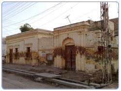
Important Buildings
- Mirza Mansoor Beg Road
- Kutchehri - Residence of Mir Sher Muhammad Talpur. Now a days being used as
Mukhtiarkar office under revenue department.
- Partab Bhawan - A palace constructed by Partab Rai. Now badly needs
restoration and preservation. It is being used as the largest girls high
school of the city.
- Ghulam Nabi Shah Hall - Now being used as District Council office.
- Durbar Hall - Used as meeting place by head of district government.
Previously and under British used as office of District Collector.
- Municipal Musafirkhana - Historical building now badly needs preservation
- Firdous Cenima Building - Established in 1938 Founder Noor Bhai Mamoojee
Currently look after Fidahussain Mamoojee Hasnain Abbas Mamoojee Murtaza
Mamoojee
- S.L.D Building - Established in 1935 Founder K.B.Ghulam Hussain
Go To Top
Historical Places
- Chitorri - Historical graveyard with many sandstone tombs of Talpur rulers
- Kahu-Jo-Darro - Ancient Buddhist archaeological site
- Jhalori- Ancient village near Jamrao Canal famous for its crops.
- Mansoor manzil which is known as cafe sheraz.
- State life building hyderabad road
Go To Top |