|
|
History |
Demography | Languages |
Interesting Places |
Parks | More Places |
Business and Industry |
Health Facilities |
The Rich Agricultural Land
 Dera Ghazi Khan is a district in the Punjab province of
Pakistan.The district covers an area of 5,306 m² and it is a long narrow
strip of country, 198 m. in length, sloping gradually from the hills which
form its western boundary to the river Indus on the east. Dera Ghazi Khan is a district in the Punjab province of
Pakistan.The district covers an area of 5,306 m² and it is a long narrow
strip of country, 198 m. in length, sloping gradually from the hills which
form its western boundary to the river Indus on the east.
Below the hills the country is high and arid, generally level, but sometimes
rolling in sandy undulations, and much intersected by hill torrents, 201 in
number. With the exceptions of two, these streams dry up after the
rains, and their influence is only felt for a few miles below the hills.
The eastern portion of the district is at a level sufficiently low to
benefit by the floods of the Indus. A barren tract intervenes between these
zones, and is beyond the reach of the hill streams on the one hand and of
the Indus on the other. Although liable to great extremes oftemperature, and
to a very scanty rainfall, the district is not unhealthy.
The Sulaiman Mountains rise to a height of 10,000 feet (3,000 m) in the
north of the district.
Search Dera Ghazi Khan on Satellite Map
Places of
Interest | Hotels
|
Eating & Dining |
Parks & Gardens
|
Educational Institutes |
Hospitals
| Sport
Centers | Banks
| ATM |
Fuel
Stations |
CNG Stations |
Police
Stations |
Shopping /Trade
History
The city was founded at the close of the 15th century and named after Nawab
Ghazi Khan Mirrani, son of Nawab Haji Khan Mirrani, a Balochi chieftain, who
had declared independence from the Langhi Dynasty Sultans of Multan.
Together with two other Deras i.e. settlements,Dera Ismail Khan and Dera
Fateh Khan, it gave its name to Derajat. Derajat eventually came into the
possession of the British after the Sikh War in 1849 and was divided into
two districts: Dera Ghazi Khan and Dera Ismail Khan. After the partition of
India, many of the city's Hindu residents settled in Derawal Nagar colony of
Delhi, India. The district of Rajanpur was later carved out of the
Dera Ghazi Khan district. Some of them also settled in various part of
India, including Bhiwani, Delhi, Jhansi, Ranchi, Ambala and Haridwar.
Dera Ghazi Khan was founded in 15th century by Amar a Tribal Sardar of
Mirani tribe. The old city of Dera Ghazi Khan was situated at the distance
of 10 miles (16 km) towards east of the present city. In 1908, the old city
of Dera Ghazi Khan was abolished due to heavy flood in theriver Indus.
Resultantly the existing city of Dera Ghazi Khan was came into being in the
year 1910. The city is divided into different blocks. The British ruler
established colonial system in the continent and declared D.G.Khan as
district in the year 1849. General Court Land was appointed as first Deputy
Commissioner of this District. Keeping in view the rapidly increasing
population of the area and deteriorating law and order situation district
D.G.Khan was divided in two districts i.e. D.G.Khan and Rajanpur. Presently
there are two revenue sub division of theDistrict. A tribal belt/political
area spread along with western side of the District. Mirani tribe has been
extinct three centuries ago. The population according to the 1901 census of
India (then a British colony) was 471,149 - the great majority being Baloch
Muslims. The frontier tribes on the Dera Ghazi Khan border include the
Lashari, Jarwar, Qaisrani, Bozdar, Khosa, Leghari, Khetran, Nutkani(Notkani)
Gurchani,Mazari, Jaskani, Marri, Mastoi, Mirani, Bugti, Malghani is part of
Nutkani or Notkani and Bamozai Known as Akhund/Akhwand tribes. Akhund (or
Akhwand) is also a surname/title used by a family in Dera Ghazi Khan,
Pakistan. Their ancestors came in from Afghanistan around 200 years ago and
settled in the old Dera Ghazi Khan. After the major floods of early 1900s
that washed away the city, they moved into the new Dera Ghazi Khan. They are
still settled in Block 11. One of the Family Member Akhund Nadir Majeed
(Late) Ex Joint Secretary PML-N was knoned as a Great Social Worker .Encyclopaedia
Britannica 11th edition published in 1911 mentions Baluchs of this area as
Frank and open in his manners, fairly truthful, faithful to his word,
temperate and enduring, and looking upon courage as the highest virtue, the
true Baluch of the Derajat is a pleasant man to have dealings with.
There are petroleum and gas reservoirs in district Dera Ghazi Khan at sites
rodho, zindapir, afiband, Dhodhak etc. The Koh-e-Sulaiman Range constitutes
a major part of this area, This range is full of naturl deposits like Marble
& Lime Stone. A big cement plant DG Cement is also situated in Kofla Sattai
Tehsil Dera Ghazi Khan.
Historical Growth
Dera Ghazi Khan city of Sohail Leghari is situated on the western bank of
the Indus river. It was founded by a Balouch ruler, nawab Haji Khan Mirrani,
also called Mirani Balouch, in 1476; he named the town after his son Ghazi
Khan Mirrani. In those days, game abounded near Dera Ghazi Khan and the
fields were green. Haji Khan Mirrani was a great cattle owner and was
attracted to the site by the plentiful supply of grass. It was known
as "Dera Phoolan Tha Sehra" due to plenty of gardens and kastori canal,
supplied by the Indus river.
In 1909-10, this cradle of Mirrani civilisation was inundated by the Indus.
At that time, there was a population of about 23,731. The present town was
built 10 miles (16 km) from the old town. It was laid out on a grid pattern
comprising 66 blocks with wide long roads and streets.Two open spaces were
planned in each block for social gatherings. Some of these have been
encroached upon.
The population of the new developed town in 1911 was 18,446. This 2.22%
decrease of population was due to dislocation of population after the
destruction of the previous settlement.
In the year 1913, the Municipal Committee came in to existence. At that
time, the area of the town was very small. Physical growth continued
and now the area was about 4 square miles (10 km2). The major growth of the
town has taken place since 1947. The town has largely spread to the north
and south; it could not expand to the west due to the danger of flooding
torrents such as affected the town in 1955. However, growth has also taken
place in the eastern side. Almost all of the new developments in north and
east of the planned town are haphazardly built.
The development in the town from 1947 to 1958 remained slow, due to lack of
transportation and communication facilities. Only a boat bridge on the river
Indus in winter season and steamer service for summer season linked Dera
Ghazi Khan with the rest of the Punjab. Taunsa Barrage on river Indus was
completed in 1953 and the pace of development gained momentum. During the
last 5 years, 72 industrial units were established. Ghazi Textile mills is
another attempt to establish a heavy industrial complex in order to raise
the economic base of the town.
Find more about
History of Pakistan
Go To Top
Demography
The city was founded at the close of the 15th century and named after Nawab
Ghazi Khan Mirrani, son of Nawab Haji Khan Mirrani, a Balochi
chieftain, who had declared independence from the Langhi Dynasty Sultans of
Multan. Together with two other Deras i.e. settlements, Dera
Ismail Khan and Dera Fateh Khan, it gave its name to Derajat. Derajat
eventually came into the possession of the British after the Sikh War in
1849 and was divided into two districts: Dera Ghazi Khan and Dera Ismail
Khan. After the partition of India, many of the city's Hindu residents
settled in Derawal Nagar colony of Delhi, India. The district of Rajanpur
was later carved out of the Dera Ghazi Khan district. Some of them also
settled in various part of India, including Bhiwani, Delhi, Jhansi, Ranchi,
Ambala and Haridwar.
Dera Ghazi Khan was founded in 15th century by Amar a Tribal Sardar of
Mirani tribe. The old city of Dera Ghazi Khan was situated at the distance
of 10 miles (16 km) towards east of the present city. In 1908, the old city
of Dera Ghazi Khan was abolished due to heavy flood in the river Indus.
Resultantly the existing city of Dera Ghazi Khan was came into being in the
year 1910. The city is divided into different blocks. The British ruler
established colonial system in the continent and declared D.G.Khan as
district in the year 1849. General Court Land was appointed as first Deputy
Commissioner of this District. Keeping in view the rapidly increasing
population of the area and deteriorating law and order situation district
D.G.Khan was divided in two districts i.e. D.G.Khan and Rajanpur. Presently
there are two revenue sub division of the District. A tribal belt/political
area spread along with western side of the District. According to the 1998
Census of Pakistan, the district had a population of 1,643,118 of which
13.76% were urban. Lund tribe is also lived at DG Khan.Nutkani(notkani)
baloch tribe is also live there and Nutkani balolch is one of ruling tribe
in this rigen under the great Nawab Asad Khan Nutkani Malghani is also part
of Nutkani.
Go To Top
Languages
Saraiki is the main language spoken in this region. Other languages that are
spoken include Urdu, Balochi, Punjabi, Pashto, and Sindhi.
Go To Top
Historical and Interesting
Places
Tomb of Ghazi Khan
The tomb of Ghazi Khan was built in the beginning of 15th century. This
seems like the tomb of Shah Rukn-e-Alam in Multan. This is present in the
Mulla Qaid Shah Graveyard. Its main gate is from eastern side and two small
doors are in side of north and south. In it there are 11 graves, which are
of the family of Ghazi Khan. Every side of the tomb is 13 feet (4.0 m) and 3
inches (76 mm) from inner side and which are conical minarets from out side.
Its circular distance from the earth is 17 feet (5.2 m) and half. The half
diameter of the conical minarets remains 34 inches (860 mm) on the highet of
19 feet (5.8 m). There are 28 ladders from northern side in the internal
side. The Graveyard came into being due to the tomb of Ghazi Khan. This is
the oldest building of the city Dera Ghazi Khan.
Church yard
In front of central jail there is a residential colony named Canal Colony.
The church yard is situated in the northern side of the colony. This is the
unique church yard which is situated in the walls on its four sides. This
church yard could not spread because of minority of the Christian in the
local area. This was came into being in the year 1910.
Shah Bagh Mosque
After the destruction of the old Dera Ghazi Khan when the people of Dera
Ghazi Khan shifted in the new city, this was the first Mosque where they
performed their first Jumma Namaz. It is in the Block No. 7. In the city
people performed their first Jumma Namaz behind the Mutawali of the
Mosque named Syed Bagh Ali Shah. So it named after the Imam of that time.
Jamia Masjid
This is the biggest Masjid of the city. Which was constructed in year 1916.
There is a large pool in the Masjid which is used for making ablution. It
has a big hall whose length is 100 feet (30 m) and width is 45 feet (14 m),
in which 3,000 persons can say their prayer at one time.Its courtyard is
also wide in which 10,000 men can say their prayer. The minarets of the
Masjid are 85 feet (26 m) high in which there are 100
ladders.
Fort Munro
 Fort Munro is a hill station in Dera Ghazi Khan which lies on the Quetta
Road at 85 km from Dera Ghazi Khan city in the Sulaiman Mountains Range. Its
altitude is 1800 meters (6,470 feet) above sea level and attracts many
people for short stays during the summer. Fort Munro is a hill station in Dera Ghazi Khan which lies on the Quetta
Road at 85 km from Dera Ghazi Khan city in the Sulaiman Mountains Range. Its
altitude is 1800 meters (6,470 feet) above sea level and attracts many
people for short stays during the summer.
Taunsa Barrage
Taunsa Barrage is situated in the northern side of the city D.G. Khan at the
distance of 60 km. It is worth seeing place. It is also a good picnic point.
Many school trips and families use to go for recreation.
Parks
D.C Garden
Its area is 81 canals and 3 marlas. Divisional Public School and Wild Life
Park was also the part of DC Garden. Although it is administrative and
residential area but it has natural greenery same like past. D.G. Khan
administration has made the D.G. Khan officers club, where the officers use
to play games like squash, badminton, and tennis. It has the beautiful
building in this area. Govt. employees, advocates,politicians, journalists,
and the local people are also the member of this club.
Company Bagh
This is called the second garden of the city. East Indian Company made the
company bagh in every district. This is known as company bagh.Its area is
162 canals and 12 Marlas. In 1948 a friends club was made in this area.
Company bagh is used to play Football, Hockey, Volley Ball, Badminton, Table
Tennis and for other games.
Ghazi Park
This is the one of the beautiful parks of the city. This is also known as
Behari Park. It is only one park of the city where the entrance is not with
out ticket. Exhibition has arranged in one time in the year since 1999. the
time of this exhibition is February to March.
The River Bank of River Indus
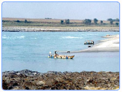 The western bank of the river Indus is a peaceful picnic point for the
peoples of D.G. Khan. From here the view of the river is looks like most
beautiful. It is also known as the name of GHAZI GHAT. Ghazi Ghat welcomes
the people of upper Punjab before entering in the city D.G. Khan. The western bank of the river Indus is a peaceful picnic point for the
peoples of D.G. Khan. From here the view of the river is looks like most
beautiful. It is also known as the name of GHAZI GHAT. Ghazi Ghat welcomes
the people of upper Punjab before entering in the city D.G. Khan.
Zoo
D. G. Khan Zoo is recently re-developed like Lahore Zoo but not as big as
the later one is. It is a good place for recreation. It has many types of
animals and birds. It is known as wild life park Dera Ghazi Khan.
Go To Top
More Places
Shopping Centres
The following shopping Markets/Centres are situated in City D.G. Khan
-
Grain market of district D.G. Khan is well renewed in
the south Punjab. Most of the farmer and traders of the region are
affiliated with the grain market. Wheat, Cotton, and Rice are the major
crops of the area
-
Rani Bazar is another business center situated in city
D.G. Khan. All kinds of jewelry and beautiful dresses of ladies are
available in this market. Mostly ladies purchase their needy articles from
this market.
-
Cloth Market is another business centre of the city and
situated in Saddar Bazar near Committee Gollai.
-
Garments Market is another business centre of the city
located in Block-10 behind Govt. City High School and situated in Anarkali
Bazar near Committee Gollai.
-
Electronic Market falls within the middest of the city
i.e. round the Gollai Committee.
-
Medicine Markets is situated near Civil Hospital D.G.
Khan. All kind of medicine are available from the market. Pakistan traders
is the wholesale supplier of all kind of medicine, serving the needs of
patients as well as medical stores.
-
Vegetable and Fruit Market is situated within the area
near the Faridi Bazar. A huge quantity of Apples, Khubani, Aalobukhara and
other kind of vegetable are being brought in this market from Bluchistan
and thereafter the same are being supplied to the other district of
Punjab Province.
-
Mobile Market is a big mobile market in heart of Dera
Ghazi Khan. Every type of mobiles and mobile related shops are in this
area.
Go To Top
Business and Industry
 The prominent employers in Dera Ghazi Khan are the D.G. Khan Cement Company,
Pakistan Atomic Energy Commission and the Al-Ghazi Tractor Company. It is
considered that these companies, along with various other flour mills,
companies in the cotton, chemical, textile industries, as well as rice,
sugar, and ghee mills, form the backbone of the Pakistan's economy. However,
private sector investment is increasing rapidly from previous few years and
a large number of Private Banks, National Corporations are offering their
services in the City. The prominent employers in Dera Ghazi Khan are the D.G. Khan Cement Company,
Pakistan Atomic Energy Commission and the Al-Ghazi Tractor Company. It is
considered that these companies, along with various other flour mills,
companies in the cotton, chemical, textile industries, as well as rice,
sugar, and ghee mills, form the backbone of the Pakistan's economy. However,
private sector investment is increasing rapidly from previous few years and
a large number of Private Banks, National Corporations are offering their
services in the City.
Go To Top
Health Facilities
In D.G Khan, there is a civil hospital called the Divisional Headquarters
Hospital, along with many private hospitals and labs.The number of
beds is being doubled from 250 to 500 in DHQ. Along with the DHQ there are
several Private Hospital working for the walfare of the People of D.G.
Khan. The overall conditions of public health are miserable in the city and
need improvement.
Go To Top
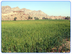
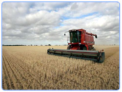
The Rich Agricultural Land
Dera Ghazi Khan is a rich agricultural land with cotton, wheat, sugarcane,
rice, tobacco being the major crops grown. Dera Ghazi Khan is also
well known for its dates. The district is now connected by railroad with
other parts of the country including Multan, Lahore, Karachi and Quetta. The
railway was built by the British before the partition of India.
Go To Top |