|
|
History |
Geography | Economy |
People and Culture | Education
|
 Kohistan in Persian, meaning "Land of Mountains" has two distinct meanings in Pakistan. In Persian "istaan" means
"land of". In its usual modern sense Kohistan District is an administrative
district within Pakistan's North West Frontier Province covering an area of
7,492 sq.kilometres; it had a population of 472,570 at the 1998 Census. In a
broader historic and geographic sense, Kohistan is used for a region that
stretches from the border with Azad Kashmir in the east to Afghanistan's
Nuristan province in the west. Kohistan in Persian, meaning "Land of Mountains" has two distinct meanings in Pakistan. In Persian "istaan" means
"land of". In its usual modern sense Kohistan District is an administrative
district within Pakistan's North West Frontier Province covering an area of
7,492 sq.kilometres; it had a population of 472,570 at the 1998 Census. In a
broader historic and geographic sense, Kohistan is used for a region that
stretches from the border with Azad Kashmir in the east to Afghanistan's
Nuristan province in the west.
Kohistan has a rich local history as a crossroads between Central, South and
Southwestern Asia. Predominantly inhabited by Dardic and Pashtun tribes
since ancient times, Kohistan has been invaded and contested by Persians,
Greeks, Scythians, Kushans, Turks, Afghans, Mughals, and the British.
Go To Top
Search
Kohistan on Satellite Map
Places of Interest
| Hotels |
Eating &
Dining | Parks &
Gardens |
Educational Institutes |
Hospitals |
Sport Centers |
Banks |
ATM |
Fuel Stations |
Shopping /Trade
History
The Kohistan of the Indus Valley, which is also called Shinkari, "the
country of the Shins" by the people themselves is inhabited by what are
apparently the remains of a number of tribes of cognate race, whose
progenitors once inhabited the valleys skirting the Punjab, and possibly
extended to the north and north west have been hitherto confounded under the
name of Dards - a name which practically, has no real signification.
Find more about
History of Pakistan
Go To Top
Geography
 Kohistan is a sparsely populated district of the North-West Frontier
Province of Pakistan.Located in an area where the Eurasian landplate and
Indian subcontinent meet and collide, Kohistan is susceptible to
earthquake activity such as the Kashmir earthquake of 2005. Kohistan is a sparsely populated district of the North-West Frontier
Province of Pakistan.Located in an area where the Eurasian landplate and
Indian subcontinent meet and collide, Kohistan is susceptible to
earthquake activity such as the Kashmir earthquake of 2005.
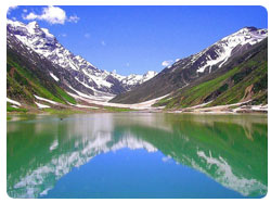
Lush green forests, meadows and streams as well as massive mountains and
hills literally make Kohistan resemble the Scottish Highlands of Britain.
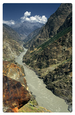
The Indus River divides Kohistan into two parts with the eastern portion
referred to as the Indus Kohistan and the western portion referred to as
Swat Kohistan. The Karakoram Highway passes through Kohistan on its way to
Gilgit. Most of the cities on the Karakoram Highway in Kohistan are not more
than 600m high from sea level.
Kohistan is one of the most isolated and the most deprived district not only
in Hazara Division but in the entire North West Frontier Province (NWFP).
Swat is situated to its west, Chilas, Darial and Tangir on the northern side
and Naran, Kaghan and Alai valley surround Kohistan from the southern and
eastern sides. It is located in the heart of the Himalayas from 34.40 to
30.35 degrees latitude and from 75.30 to 50.72 degrees longitude.It is
connected with Dir via the Badawi Pass.
The River Indus flows through Kohistan and divides it socially and
culturally. Kohistan is one of the least developed districts in the country
and its national significance is the Karakurum Highway. This road is the
main source of trade, transportation and link between Pakistan and China.
The ancient Silk Road has long been a thoroughfare for tourists, traders and
conquerors from Central Asia and in the past, business delegations would use
this passage to travel up to Europe and Little Asia (Kochak).
Kohistan is where the Hindukush, Karakuram and Himalayan mountain systems
meet and serve as
a natural boundary for environmental regions in the chains of the Himalayas,
Karakoram and Hindu Kush mountains. This uniqueness of the mountains system
also results in rich flora and fauna and therefore gives home to unique
species such as the Western Tragopan pheasant and the Snow Leopard.
Go To Top
Economy
 Most Kohistanis rely upon animal husbandry for sustenance and income and
tend to use cows, sheep, goats for milk and meat. In addition, the timber
industry is on the rise, while many local men travel to find work in
Peshawar, Islamabad, Lahore, and Karachi. Most Kohistanis rely upon animal husbandry for sustenance and income and
tend to use cows, sheep, goats for milk and meat. In addition, the timber
industry is on the rise, while many local men travel to find work in
Peshawar, Islamabad, Lahore, and Karachi.
The people in Kohistan largely depend on livestock for their livelihood and
this is also the reason for their seasonal migration to sub-alpine and
alpine pastures of Kohistan and neighbouring valleys and districts.
Agriculture development is comparatively poor with only one crop growing in
high altitudes and two in the lower areas. Cultivation of crops such as
barley and rice has almost been given up.
People usually keep buffaloes, cows, sheep, goats and bullocks. Milk of
these animals is not usually sold, but by-products of milk such as butter,
are. Other by-products such as wool and skin are utilized for
house-consumption and are also sold in the market.
Cash income is rare and people resort to the sale of timber, such as Deodar,
Pine, Spruce,Acacia and Oak. Sale of medicinal herbs is also common though
there is no check, which impact the seasonal removal of these plants has on
the overall population of the species or on the health of the ecosystem.
Besides this, people are also involved in the sale of fuel-wood, farm
products such as walnuts and walnut bark (vernacular: dindasa). Honey is
also sold in local and provincial markets. In winter season, the local men
go to urban areas in search of work.
Find more about
Worldwide
Business & Economy
Go To Top
People and Culture
 Kohistan's population is estimated to be over 500,000 and is spread across
the various towns and villages. Kohistan is predominantly home to various
Dardic peoples including the Shina, Kohistani, Torwalis, as well as minority
Hindko-speaking in the central, northern, and eastern sections. The people
mainly speak Indo-Iranian languages and share various similar cultural
traits including the religion of Islam with the majority adhering to the
Shia sect while large minorities of Sunni and Ismaili Muslims are also to be
found throughout the area. Pashtuns makes up half the population of the
district, but are mostly settled in the west. Kohistan's population is estimated to be over 500,000 and is spread across
the various towns and villages. Kohistan is predominantly home to various
Dardic peoples including the Shina, Kohistani, Torwalis, as well as minority
Hindko-speaking in the central, northern, and eastern sections. The people
mainly speak Indo-Iranian languages and share various similar cultural
traits including the religion of Islam with the majority adhering to the
Shia sect while large minorities of Sunni and Ismaili Muslims are also to be
found throughout the area. Pashtuns makes up half the population of the
district, but are mostly settled in the west.
According to the Census of 1981, the population of the district of Kohistan
was 465,237; by 1998 this grew to 472,570. The average literacy rate is
around two percent, but the actual literacy rate based on field data shows
that this rate is three times more.
The geographic location, lush green valleys adorned with rich flora and
fauna were the biggest attractions for external invaders. It was also the
only passage between China and South East Asia; the area remained under
constant attacks by Tibetans, Sikhs, and Hindus. This constant invasion
resulted in one of the most distinctive societies and cultures in the
region, “The Rebellion Culture”. This is the main characteristic of Kohistan,
and its people are still following the same culture.
Find more about
Culture of Pakistan ,
People, Art & Culture
Go To Top
Education
View Educational Institutes on satellite Map
Kohistan's literacy rate is amongst the lowest in Pakistan and hovers around
10%, but education is slowly expanding due to government efforts. After the
arrival of Pakistan's Army for relief operations following the earthquake of
October 2005, the educational system received a sudden boost-up, and most of
the schools are working. The Army's commanding Officer of the area, Lt. Col.
Sibghat Ullah, took responsibility for one school in Pattan (The Army
Garrison School which has become a role model for the complete district.
In total there are four Army supported schools established in Kohistan,
which include the Army School for Girls, Shalkanabad (Palas); the Army
School for boys, Keyal; and the Community
Model School for girls at Pattan.
After the departure of the Pakistan Army from the area, the standard of the
schools could not be maintained by the local authorities, and thus the
standards declined. The Most Influential Tribe of Kohistan Is Shalkan
Khail.The Most educated And Influential Person of District Kohistan
Is Asghar KHan Kohistani Shalkan Kheil.
Find more about
Worldwide Education
Go To Top |